
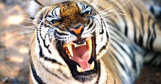
- Corbett Tiger Reserve
- Elephant Safari in Corbett
- Bird Watching in Corbett
- Corbett Walking Tour
- Fishing in Corbett
- Wildlife Viewing
- Community
- Gettingthere
- Contact us

 Home ::
Corbett Tiger Reserve
Home ::
Corbett Tiger ReserveCorbett Tiger Reserve
Time: 4 - 5 days
Season: November to March
Grade: Moderate
Region: Kumaon foothills of Nainital, Uttaranchal
Altitude: 450 m to 2525 m
Unlike most other treks that are done in summers for easier access,
this trek is best enjoyed around winter months as high altitude birds
migrate to lower regions and the forests are in bloom. This forest
trek has an altitudinal variation of 450 m to 2500 m, giving the whole
region a diverse bird and mammal life. An astounding 650 bird species
have been reported here and the assemblage of mammals is equally impressive,
the most notable being the elusive Serow. Highly recommended for beginners,
this is a moderate trek through beautiful natural surroundings. You
hike along old pony trails, camp at scenic spots or stay in colonial
era forest bungalows. Starting from the right bank of the Kosi River
this trek leads through dense broadleaf forest rich in wildlife, forging
through shallow streams. As we gain altitude, vegetation & landscape
go through considerable change and you move on to conifer forests
of oak and pine that open into scenic valleys & gorges. You finally
end the trek at temperate forest higher up that offer spectacular
views of the icy Himalayas along the way. What is quite remarkable
is the ever-changing biodiversity, rich wildlife and the dramatic
difference in forest types each day. You pass through small villages
and hamlets, where you can see people lead a simple symbiotic life
in harmony with their wild surroundings.
Day 1 Kumeria to Akashkhanda
Time: 8 hours
Level: Moderate
The trek begins at Kumeria from where a suspension bridge over the
Kosi leads you to the trail that cuts right through the relatively
large riverside village of Kunkhet. After crossing the village we
went up the irrigation canal, which ran parallel to the river for
about half an hour, before reaching the head of the canal. From here
we climbed uphill through a narrow broken trail that soon merged with
a fire lane and led to the village of Okhaldhunga (500m). Soon after
crossing the village we came across the old district board road that
meanders along the Kosi. Still used by villagers to carry supplies
on packhorses and mules, this is a fairly broad trail and leads to
the village of Babas (600m). There is a small tea stall here, which
is of strategic importance because it is the only one in the area.
From here the vegetation gets scanty and the steep ascent can get
quite exhausting by the time you reach the small village of Mon. The
verandah at the primary school of Mon is a welcome site to rest for
a while. After Mon the trail gets narrow and the climb gets steeper.
The vegetation transforms to coniferous forest from here all the way
till the campsite at Akashkhanda (1600 m).
Day 2 Akashkhanda to Kunjkharak
Time: 6 hours
Level: Easy
Being miles away from road, the forest bungalow at Akashkhanda is
seldom visited by tourists or even forest officials. Though in a dilapidated
state now, this beautiful bungalow is set amidst pine trees and offers
complete solitude. On a clear day you get spectacular views of Nanda
Ghunti (20,700 ft) and Trishul (23,360 ft). From here the trek took
us to dense temperate forests dominated by oak, chestnut and rhododendron,
which is a riot of red when in bloom. Birds commonly seen here include
the colourful Jays, Magpie and Thrushes. This area also supports rich
mammal life; on the hill slopes you can try to spot the ghoral (goat
antelope) and on the trail you stumble upon the occasional pugmarks
of the leopard. The last part of the hike is quite steep though enjoyable
as the temperature begins to drop and the views get spectacular. We
camped for the night at the clearing in the forest department compound
of Kunjkharak, kharak in Kumaoni meaning pass.
Day 3 Kunjkharak to Vinayak (16 km)
Time: 5 hrs
Level: Easy
Since this area is actually a high pass, it can get very windy and
winter temperatures may drop to 0 degrees, with occasional snowfall
in the area. Huge rocks in forested ridges make it a good place to
sight high altitude birds like Lammergeier, Himalyan and Eurasian
Griffon. Other raptors you may see are Tawny Eagle, Steppe eagle and
Kestrel. From here we approached the main trail that ran all along
the ridge to Vinayak, our next campsite. Though this is a motorable
track, chances of coming come across any vehicle are very slim indeed.
Barely a kilometer after Kunjkharak you get a magnificent 380 km broad
view of the Himalayan range. A unique feature of this moist temperate
forest is the Khoola moss that carpets the floor below. This moss
absorbs water and helps in retaining moisture in the forest. However,
due to indiscriminate extraction and collection for its use in several
cosmetic products, this moss has become highly endangered. At Vinayak
(2300m) you stay in the beautiful forest bungalow (booked from DFO
Nainital) or camp out in the compound of the nursery. Evenings are
magical as the setting sun transforms the icy Himalayas across Vinayak
into gold.
Day 4 Vinayak - Pathariya
Time: 9 hours
Grade: Easy
In the morning we hiked to the highest ridge of Vinayak (2600m) that
started from right in front of the bungalow. This day's trek took
us through one of the finest patches of cedar forest, crisscrossed
by streams. Here is your best chance to find the elusive serow and
while you do so look out for signs of the Himalayan Black Bear. An
hours' hike takes us to the top of the ridge for a stunning view of
the Himalayas. From here we moved onwards on a narrow trail and headed
southeast along the ridge to get to the main road at Sigri (2350m).
We walked the next 3 km on an unpaved road till a culvert ahead of
Guhugu Khan, from where a right turn onto a pony trail took us to
the tiny but well-stocked market of Pangot (2150 m). Situated in a
pass, this market served as an important trading center between the
valleys in olden days. From here we took the trail that went along
the southern end along dense oak forests with undergrowth of Ringal,
bamboo and ferns. A long hike through rich forests offers the chance
to encounter a variety of wildlife such as barking deer, Khaleej and
Koklass Pheasant. This forest is of great ornithological importance
as the once considered extinct Himalayan Quail was reported here.
The search to discover it is still on. We finally got to the popular
Naina peak (2600 m), earlier known as Cheena Peak. From here we took
a trail to the right heading downhill to Pathariya (2200m). A magical
spot that offered a birds' eye view of Nainital, this was where we
set up camp and went to sleep as the glittering lights of Nainital
slowly dissolved into darkness.
Day 5 Nainital and around
If you have had enough of camping out you can leave Pathariya at the
end of Day 4 and opt for the comforts of one of the many hotels at
Nainital, which is just a short walk away. The main hub of Nainital
is the Naini lake, which according to a mythological story marks the
spot where Sati's eye fell and thus reflects its emerald green colour.
A temple dedicated to Naina Devi lies on the edge of the lake. While
Nainital is a bustling township and offers many tourist distractions
like boating on the Naini lake and shopping in its busy streets, you
must take time out to visit Guerney House, the place where the legendary
Jim Corbett was born.